There has been very little researched information available about the early Native Americans in Granite County. This article will attempt to collect and discuss what is known about tribal history, anthropology, and archaeological documentation. Because the information is constantly changing with all the new DNA evidence and newly discovered artifacts, plus identification of the mineral compositions and sites, this article could easily be outdated by the time it is published. Fortunately because it is in a blog format, changes can be made as new information is confirmed.
As an introduction to known Montana Native history, first will be a discussion of the Anzick Child. In 1968 a small boy's skeleton was found buried northeast of Livingston, near Wilsall, Montana. Also found at this site was a cache of distinctive ancient stone tools that archaeologists call "Clovis Culture." This designation is named after the town in New Mexico where similar tools were first found. Archaeologists originally dated these tools to be used from 9,200 BC to 8,900 BC ("The First Americans",p.19,1992). Recent scientific advances with DNA testing has shown that the Anzick Child is the earliest known human inhabitant of Montana, dating about 12,600 years ago. Genetic work by Archaeologists (including Susan Anzick) has shown that he is closely related to the various North and South American Native American tribes (Associated Press, February 13, 2014). The Flathead online website states that recently archaeologists found sites on the south fork of the Flathead River dating back 12 to 14,000 years (about the time of the last ice age). I have been unable to find any published report on this finding.
The earliest site of human habitation positively identified in our immediate area is at Avon, where charcoal associated with stone tools has yielded a radiocarbon age of about 7,500 BC. Whether these early natives inhabited the area or only traveled through hunting, fishing, trapping or gathering is not certain. Little is known about this population ,named Paleoindians by Archaeologists.
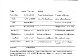
A table of the various periods and names follows:

Use this diagram to help visualize the article discussion while recognizing that dates are very fluid. Some Archaeologists speak of BP "Before present' meaning really about 1950, others speak of B.C. and A.D., so always recognize that 12,000 years before present means about 12,000 years before 1950 or about 10,050 BC.
Archaeology of the Bearmouth area west of Drummond was first documented by Granite County resident Patricia Flint (Lacey). In her Master Thesis at the University of Montana (1977) Patricia drew pictures of the various tools found in the six aboriginal occupation sites, two quarry sites and two religious shrines, located along the Clark Fork River. Included in her report was "The Weaver Site" first reported in the Hell Gate Survey in 1952. This site is named after the pioneer Weaver family who have lived first in Deer Lodge County and then Granite County since about 1876.
Flint's conclusions are well documented in her thesis at: http://scholarworks.umt.edu/cgi/viewcontent.cgi?.article=2612&.content_edt.
She believed there were many tribes using the Bearmouth area with the Semte'use being the earliest identifiable group who left the majority of Prehistoric remains. Interested persons can request viewing of the Bearmouth artifacts at the Granite County Museum in Philipsburg.
We know that long before silver and gold was mined in Granite County, "flint" was a valuable resource to the early inhabitants. They developed the stone quarry northwest of Maxville at the "Eyebrow." Tons of Chalcedony (which is informally called Flint) was quarried there, apparently for many centuries. This site is the reason the creek just to the east is called Flint Creek. On a Hudson Bay Map related to a fur trapping expedition through Granite County in 1825, the river now know as Clark Fork is called Arrowstone River. This name was also derived from the flint quarry on the tributary.
Christine Quintasket under the name Morning Dove (1866-1936), had a Hudson Bay Trapper father and an Okanogan (Salish) mother. She was enrolled in the Colville Tribe of Northern Washington and compiled a book of "Coyote Stories". This book was originally published in 1933 and cites a Folk Story titled "Why Flint-Rock cannot fight back"( pp.73-77). She states that the Hill now known as Square Butte in Cascade County, Montana is where all the flint came from. We now know that her story is just that- a story, because the "flint' found in various quarries around Montana are of varied mineral compositions such as Madison Chert and Hasmark Chalcedony. McDonald in "Montana Before History" (2012), calls the early Native Americans that developed these quarries "the earliest Hard Rock Miners."
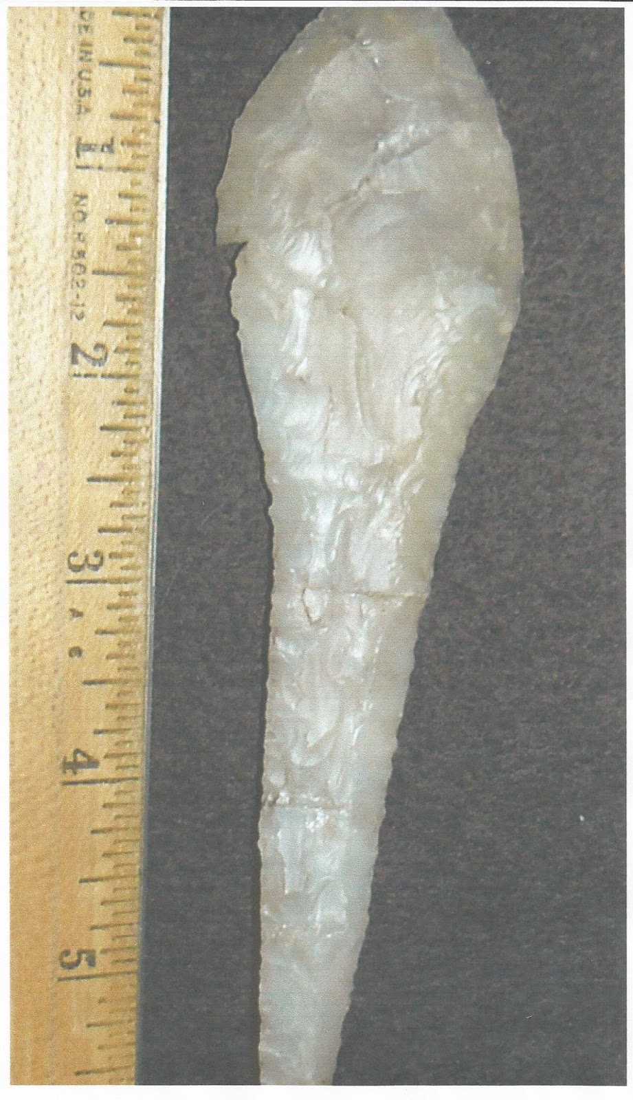
Through out the years, pioneer ranchers, miners and hunters have found various native artifacts such as Bison Antiquus Skulls, stone tools, projectile points and knives in Granite County. Stories about Indian graves are known by many descendants. After a number of artifacts had been found while digging a garden or picking rocks from hayfields, a dig was executed at the Budel Ranch south of Philipsburg near the lower Fred Burr Creek in 1989. Coordinated by Jack Schulz a Butte Anthropologist and five Montana Tech Students (and volunteers totaling about 20 people), they found several arrowheads, bones and stone tools. The artifacts were believed to be more than 3,000 years old (Montana Standard, August 20,1989, p.17). The site is registered with the Montana Historical Preservation Office and numbered 24GN1095. The land owner, Marlene Chor, Ken Schmidt (Site manager), Anthropologist, Mark Schmidt (Senior Advisor), Psychologist and Daniel Comer MA (Project Director) Archaeologist, graduate of UM (2005) are currently involved at the site. Digging has occurred almost yearly for the past fifteen years. The site is believed to be a Bison processing area with the finding of almost every bone occurring in a Bison skeleton. Numerous other large and small animal species bones have also been found. There was a large number of small faunal fragments found in a hearth near a large number of pottery sherds, indicating that bones were being boiled to obtain bone broth. Tools found at the site are from many sources. There are a minimum of eight tools types, that may be from as far away as Boise, Idaho. The site has yielded 396 total field specimens as of 2015. Maize (corn) was also found and so far is the only site where it has been discovered in Western Montana. This finding indicates people from southern regions were at least visitors to this area. Rare micro drills have been found along with samples of every major projectile point style ranging from Archaic up to Prehistoric time frames. Artifacts found to this date appear to be from 0 to 1500 B.C. and then again from 1300 to 1850 A.D. Pictured below is a Shoshone Knife/Awl found in broken pieces that was able to be fully reconstructed. According to Daniel Comer the stone used for this artifact came from the McCleery Gulch Quarry by Silver Bow Creek near Rocker. There has been eleven tools of this material and a total of 105 pieces (debitage) of this type found at the Fred Burr site.

Next are a display of bones and points found in 2013 and photographed in 2014:

At least two bones have been found with "tally marks" keeping track of unknown data. The site has revealed the only known clay ball found in Montana and there are very rare post molds that must have been used for drying racks. So far the site has revealed over 100 hearths with two extremely well formed and preserved baking ovens. The point pictured below is called "Pelican Lake" style. Daniel Comer states the material used to make this point probably came from The "Devil's Eyebrow" on Flint Creek.

All of this data adds to our body of knowledge about what Native American Tribes either utilized or inhabited this area, before the white man arrived. According to the Flathead Nation, ancestors of the Salish (Selish) Tribes are believed to be the first known people east of the "Bitter Root, in the Big Hole, The Butte area, Helena area, and Three Forks vicinity." One of their tribes, the Pend d' Oreilles were on both sides of the Continental Divide, with a major band situated by the Sun River near Great Falls (Flathead Reservation, p.25, online www.opt.mt.gov).Place names that are of Salish language are as far east as Sweetgrass Hills, the Milk River and the Bear Paw Mountains. The word Salish means "The People". McWhorter in "Hear Me My Chiefs" (1952) states that the Nez Perce people believe Duncan McDonald, whose mother was a Nez Perce, and was emphatic that the word is pronounced Selish, not Salish.
James Teit (1864-1942), Frank Boas (1858-1942), Livingston Farand (1867-1939), Marion K. Gould and Herbert J. Spinden (1879-1967) compiled a book of "Folk Tales of Salish and Sahapin Tribes" (1917), containing 283 tales from their interviews with Native Tribes. The majority have Coyote as the central character. Often the tales are similar when recited from different tribes and many have themes that follow biblical stories.
The most extensive documents about the "Salishan Tribes of the Western Plateaus" are credited to Teit who was sponsored by Franz Boas, a German-American Anthropologist. James was born in Scotland and moved to British Columbia at the age of 19 in 1884. He was a clerk at his uncles store and became a guide for big game hunters. He married a Native Indian of the Thompson Tribe from a small village near Spences Bridge in Canada. Because he was locally known as an expert on the language of the Thompson Tribe, Franz Boas was directed to him while on an ethnographic field trip in 1894. This began a long relationship, with Teit performing many tribe assessments and documenting the information. By the time of his death, James had published over 2,200 printed pages in 43 sources and had almost 5,000 more unpublished manuscripts.
In Teit's discussion of the Salish, he states "They say that long ago there were two tribes or people inhabiting the Flathead country. One of these was called the "Leg people" and the other "Flathead (or Wide Head) people."...It seems the Leg People were originally entirely east of the range. In later years the two tribes lived together. The Wide Head tribe was smaller than the Leg Tribe. Finally the former disappeared. Possibly they ceased pressing their heads so they could no longer be distinguished, or they may have been absorbed by the Leg People (p.295).
Describing the habitat and boundaries of the Flathead and Salish tribes, Teit identifies two Salish tribes who originally lived entirely east of the Continental Divide; these were the Flathead and Salish Tuna'xe. Both Flathead and Pend d' Orielle informants provided the same information. The large detached bands made their headquarters close to the east slope of the Divide and occasionally traveled west of the Divide into the counties now known as Ravalli and Granite, but never crossed the Bitter Root Range. During the summer months the different bands traveled as far east as Bozeman and northward to the Belt Mountains. Their territory included all the present counties of Deer Lodge, Silver Bow, Beaverhead, Madison, Gallatin, Jefferson and Broadwater counties and parts of Park, Meagher, and Lewis and Clark. These areas were said to be inhabited by the Flat Heads about 1600 when they first obtained the horse.. But I cannot find any source stating the Flat Heads had horses in 1600. Bordering them was the Pend d'Orielles, Semte'use and Tuna'xe. on the northwest and north and the Shoshonean Tribes all around them on the southwest, south and east. During this time the Crow, Gros Ventres, Arapaho, Assiniboines and Cheyenne were not in Montana (p.304).
H. Turney-High, an Anthropologist, who began publishing papers on the Flathead Indians in 1942, discounts a lot of Teit's information and interviews. If the reader takes into account the three and four decades that passed between Teit and Turney-High's interviews there must have been a major change in the tribe elders and memories during these major years of World War's and reservation life. A 1948 Thesis written by Vernon Malan at the University of Montana on "Language and Social Change among the Flathead Indians" interviewed Pierre Pichette during March through May of 1948. Pierre was born on September 19, 1876 and was educated at the St. Ignatius Mission School. Although blind by the time of the interviews, Pierre had excellent memory recall and was well educated on the Flathead history. Malan states "besides telling what he knew about the topic which this study is concerned, Pierre checked many of the sources quoted in this study. After having them read to him, he was able to point out inaccuracies and in some instances reject parts of the literature. For instance, he rejected legends quoted by Turney-High in his study as not well known or important to the mythology of the tribe, and he felt that legends which were known to him were misrepresented to some extent. Turney-High indicates that the people of the legends, the dwarfs and giants and foolish folk, were considered by the people of the tribe to be real people. Actually, Pierre says that they were mere stories of spirit people invented for entertainment" (p.VIII). Below is a map of the area's believed to be inhabited by the Native tribes during the 1600's. This depiction is hand drawn by Loraine Bentz Domine.
 1. Semte'use inhabited this area from about 1600 to before 1800
2. Eastern Salish (Selish) known as Flathead and Semte'use inhabited this area (Anthropologists uncertain) from about 1600 to 1780's.
3. A Flathead Tribe who later moved to Camas Prairie (Dates uncertain)
Teit describes the area of the Semte'use as "immediately west of the Rocky Mountains, in what is now Powell County, and in parts of Lewis and Clark, Missoula and Granite County. Their southern boundary seems to have run in a line from Garrison or Deer Lodge to Missoula and their western boundary northeasterly to a point of the Rockies in the neighborhood of the northern end of Powell County, their property thus forming a wedge to the north. The former ownership of the triangular piece of country forming the southern part of Granite County, with Philipsburg as the center, is uncertain, but it probably belonged to the Semte'use...(they) were entirely surrounded by Salish Tribes--The Salish Tuna'xe on the east, the Flathead on the South and the Pend d'Orielles's on the west" (pp.306-307). John R. Swanton, in " Indian Tribes of North America", states "the Semte'use (a former tribe from the Salishan stock) had a band living on the Blackfoot River, another at Camas Prairie and a smaller band headquartered near Deer Lodge and there may have been one at Philipsburg." Others were said to have lived on the Little Blackfoot and the Salmon-Trout Rivers.
Patricia Flint documents in her Thesis "The ethnohistoric evidence indicates multi-tribal use of the Bearmouth area. The Semte'use, a branch of Pend d' Orielle, were probably the earliest identifiable inhabitants of the area and left most of the prehistoric remains, uncovered in this archaeological survey. Before the introduction of the horse..., they utilized the Bearmouth area on a regular basis to the exclusion of most other tribes" (p. 95).
When the Semte'use were either decimated by disease or warfare the Flathead moved into the area. The Flathead Reservation Timeline (2010), cites the following:
Below is a picture of Flathead Indians camped near Marshall Creek in 1892. (The Tex Crowley Collection in the possession of LouAnn Fessler Sichveland)

The Nez Perce is another important Tribe that utilized this area. L.V. McWhorter lived among the Nez Perce for most of thirty years while writing his books such as "Yellow Wolf" (1940) and "Hear Me My Chiefs" (1952). This probably made him an expert on the culture of the tribe. Wottolen (Hair combed over eyes), a blind old warrior gave McWhorter this explanation of the origin and early growth of the Nez Perce:
The Nez Perce became adept at traveling to the Pacific Coast and using Chinook Jargon traded with the coastal tribes for sea shells, dentalium and baskets, then they traveled to the Plains area where they traded the coast items for beads, buffalo hides and beaded items including feathered dance regalia, while using sign language. They are the only known trade group from the Plateau Natives.
Gulick (1981) references Slickpoo and Walker in "Noon Nee-me-poo (We the Nez Perces): Culture and History of the Nez Perces", Vol.I, 1973,p.5 with the statement "Archaeologists now tell us that we have been living in America upwards of twenty to thirty thousand years." This statement was published for the Nez Perce Tribal Council, Lapwai, Idaho. I have been unable to find the original publication.
The elders speaking to McWhorter believed the Nez Perce obtained their first horses about 1710. Prior to being introduced to the horse the entire tribe including children and dogs all carried packs on their backs. Sometimes these trips took more than one to two years to complete (Gulick, "Chief Joseph Country",1981). Being excellent traders it was only natural when they learned of the Shoshonean Tribes having horses, that they set out to barter for this important animal. The elders have a number of different stories about how the first horses were obtained. One story quoted in Gulick is referenced from Haines, " Appaloosa: The spotted horse in art and history,"( 1963,p. 68) and states:
Because traveling was an important part of the Nez Perce culture, Granite County was often traveled through. There is no evidence that this tribe ever lived in the area but we know they passed through. The Old Nez Perce Trail drops into the Bitterroot Valley west of what is now know as Sula and also the Lolo Trail comes over the Biterroot Mountains eleven miles south of the Hell Gate (Missoula). The tribe is known to have utilized the Skalkaho and Ross Fork and probably the Burnt Fork Trail. Elder's interviewed by McWhorter speak of hunting buffalo, first in the Salmon area then the Bitterroot and later across the Continental Divide. It stands to reason that mountain passes were found to cut down on the miles originally traveled on foot carrying backpacks.
Nez Perce, Shoshone, Flathead and Pend d'Orielle women were in relationships with trappers, traders and miners in the area. Granville Stuart and Fred Burr were married to Shoshone sisters; James Stuart had a relationship with Susan Michel, a Nez Perce, producing a son James. To read more about this go to the James Stuart blog article. Major John Owen married a Shoshone; Peter Skene Ogden married a Flathead; Sternie Blake married the daughter of a Shoshone chief who was raised by Major Owen and his wife Nancy, and the list goes on. I bring this up to reinforce the fact that artifacts from the Shoshonean Tribes and others found at the Budel site are not abnomalies. These tribes frequented Granite County and hopefully as more information is obtained we will learn how many thousands of years the county has been inhabited, and by whom.

At least two bones have been found with "tally marks" keeping track of unknown data. The site has revealed the only known clay ball found in Montana and there are very rare post molds that must have been used for drying racks. So far the site has revealed over 100 hearths with two extremely well formed and preserved baking ovens. The point pictured below is called "Pelican Lake" style. Daniel Comer states the material used to make this point probably came from The "Devil's Eyebrow" on Flint Creek.

When Mr. Comer has all the artifacts documented they are to be archived at the Granite County Museum for availability to future study.
All of this data adds to our body of knowledge about what Native American Tribes either utilized or inhabited this area, before the white man arrived. According to the Flathead Nation, ancestors of the Salish (Selish) Tribes are believed to be the first known people east of the "Bitter Root, in the Big Hole, The Butte area, Helena area, and Three Forks vicinity." One of their tribes, the Pend d' Oreilles were on both sides of the Continental Divide, with a major band situated by the Sun River near Great Falls (Flathead Reservation, p.25, online www.opt.mt.gov).Place names that are of Salish language are as far east as Sweetgrass Hills, the Milk River and the Bear Paw Mountains. The word Salish means "The People". McWhorter in "Hear Me My Chiefs" (1952) states that the Nez Perce people believe Duncan McDonald, whose mother was a Nez Perce, and was emphatic that the word is pronounced Selish, not Salish.
James Teit (1864-1942), Frank Boas (1858-1942), Livingston Farand (1867-1939), Marion K. Gould and Herbert J. Spinden (1879-1967) compiled a book of "Folk Tales of Salish and Sahapin Tribes" (1917), containing 283 tales from their interviews with Native Tribes. The majority have Coyote as the central character. Often the tales are similar when recited from different tribes and many have themes that follow biblical stories.
The most extensive documents about the "Salishan Tribes of the Western Plateaus" are credited to Teit who was sponsored by Franz Boas, a German-American Anthropologist. James was born in Scotland and moved to British Columbia at the age of 19 in 1884. He was a clerk at his uncles store and became a guide for big game hunters. He married a Native Indian of the Thompson Tribe from a small village near Spences Bridge in Canada. Because he was locally known as an expert on the language of the Thompson Tribe, Franz Boas was directed to him while on an ethnographic field trip in 1894. This began a long relationship, with Teit performing many tribe assessments and documenting the information. By the time of his death, James had published over 2,200 printed pages in 43 sources and had almost 5,000 more unpublished manuscripts.
In Teit's discussion of the Salish, he states "They say that long ago there were two tribes or people inhabiting the Flathead country. One of these was called the "Leg people" and the other "Flathead (or Wide Head) people."...It seems the Leg People were originally entirely east of the range. In later years the two tribes lived together. The Wide Head tribe was smaller than the Leg Tribe. Finally the former disappeared. Possibly they ceased pressing their heads so they could no longer be distinguished, or they may have been absorbed by the Leg People (p.295).
Describing the habitat and boundaries of the Flathead and Salish tribes, Teit identifies two Salish tribes who originally lived entirely east of the Continental Divide; these were the Flathead and Salish Tuna'xe. Both Flathead and Pend d' Orielle informants provided the same information. The large detached bands made their headquarters close to the east slope of the Divide and occasionally traveled west of the Divide into the counties now known as Ravalli and Granite, but never crossed the Bitter Root Range. During the summer months the different bands traveled as far east as Bozeman and northward to the Belt Mountains. Their territory included all the present counties of Deer Lodge, Silver Bow, Beaverhead, Madison, Gallatin, Jefferson and Broadwater counties and parts of Park, Meagher, and Lewis and Clark. These areas were said to be inhabited by the Flat Heads about 1600 when they first obtained the horse.. But I cannot find any source stating the Flat Heads had horses in 1600. Bordering them was the Pend d'Orielles, Semte'use and Tuna'xe. on the northwest and north and the Shoshonean Tribes all around them on the southwest, south and east. During this time the Crow, Gros Ventres, Arapaho, Assiniboines and Cheyenne were not in Montana (p.304).
H. Turney-High, an Anthropologist, who began publishing papers on the Flathead Indians in 1942, discounts a lot of Teit's information and interviews. If the reader takes into account the three and four decades that passed between Teit and Turney-High's interviews there must have been a major change in the tribe elders and memories during these major years of World War's and reservation life. A 1948 Thesis written by Vernon Malan at the University of Montana on "Language and Social Change among the Flathead Indians" interviewed Pierre Pichette during March through May of 1948. Pierre was born on September 19, 1876 and was educated at the St. Ignatius Mission School. Although blind by the time of the interviews, Pierre had excellent memory recall and was well educated on the Flathead history. Malan states "besides telling what he knew about the topic which this study is concerned, Pierre checked many of the sources quoted in this study. After having them read to him, he was able to point out inaccuracies and in some instances reject parts of the literature. For instance, he rejected legends quoted by Turney-High in his study as not well known or important to the mythology of the tribe, and he felt that legends which were known to him were misrepresented to some extent. Turney-High indicates that the people of the legends, the dwarfs and giants and foolish folk, were considered by the people of the tribe to be real people. Actually, Pierre says that they were mere stories of spirit people invented for entertainment" (p.VIII). Below is a map of the area's believed to be inhabited by the Native tribes during the 1600's. This depiction is hand drawn by Loraine Bentz Domine.

2. Eastern Salish (Selish) known as Flathead and Semte'use inhabited this area (Anthropologists uncertain) from about 1600 to 1780's.
3. A Flathead Tribe who later moved to Camas Prairie (Dates uncertain)
Teit describes the area of the Semte'use as "immediately west of the Rocky Mountains, in what is now Powell County, and in parts of Lewis and Clark, Missoula and Granite County. Their southern boundary seems to have run in a line from Garrison or Deer Lodge to Missoula and their western boundary northeasterly to a point of the Rockies in the neighborhood of the northern end of Powell County, their property thus forming a wedge to the north. The former ownership of the triangular piece of country forming the southern part of Granite County, with Philipsburg as the center, is uncertain, but it probably belonged to the Semte'use...(they) were entirely surrounded by Salish Tribes--The Salish Tuna'xe on the east, the Flathead on the South and the Pend d'Orielles's on the west" (pp.306-307). John R. Swanton, in " Indian Tribes of North America", states "the Semte'use (a former tribe from the Salishan stock) had a band living on the Blackfoot River, another at Camas Prairie and a smaller band headquartered near Deer Lodge and there may have been one at Philipsburg." Others were said to have lived on the Little Blackfoot and the Salmon-Trout Rivers.
Patricia Flint documents in her Thesis "The ethnohistoric evidence indicates multi-tribal use of the Bearmouth area. The Semte'use, a branch of Pend d' Orielle, were probably the earliest identifiable inhabitants of the area and left most of the prehistoric remains, uncovered in this archaeological survey. Before the introduction of the horse..., they utilized the Bearmouth area on a regular basis to the exclusion of most other tribes" (p. 95).
When the Semte'use were either decimated by disease or warfare the Flathead moved into the area. The Flathead Reservation Timeline (2010), cites the following:
1780-A smallpox outbreak reached a group of Salish camped in the Missoula area. The camp divided- families with smallpox and those without. One group went to the Bitterroot valley while the other moved to the Drummond area. Only one boy in the Bitterroot camp survived the epidemic. By 1782, small pox had killed an estimated one-half to three-quarters of the Salish and Pend d' Orielle bands. The combination of the introduction of disease, firearms and horses led to massive changes in the intertribal territories. Blackfoot expansion caused the eastern bands of the Salish and Pend d'Orielle to move their winter camps west of the Continental Divide. The Salishan people called the Tuna'xe, who occupied the Rocky Mountain front, were decimated. The survivors scattered to the west and merged with other tribes, bringing about near extinction of a native people" (p.1).As early as 1650 to 1700, the Shoshonean Tribes had ranged into Canada with their horses. (Ontko, Thunder over the Ochoco, Vol.I, 2007, p.27). The Blackfoot Tribe of Canada who ranged around Slave Lake either captured stray horses or raided the Shoshone camps and became a mounted tribe. With horses and their warrior instincts, the Blackfoot moved steadily southward and by the time Lewis and Clark (1805-1806), came through the Missouri and Marias River area, encounters were made with their warriors. The Northwest and Hudson Bay Fur Traders had numerous encounters with the Blackfeet as far south as Idaho in the early 1800's and by the time Major John Owen and the Jesuit Missionaries settled in the Bitterroot in the 1840-50's everyone was afraid of encounters with these warriors. Fred Burr and the Stuart brothers describe many losses of horse, cattle and oxen to the Blackfoot prior to 1865, including in the Flint Creek Valley.
Below is a picture of Flathead Indians camped near Marshall Creek in 1892. (The Tex Crowley Collection in the possession of LouAnn Fessler Sichveland)

The Nez Perce is another important Tribe that utilized this area. L.V. McWhorter lived among the Nez Perce for most of thirty years while writing his books such as "Yellow Wolf" (1940) and "Hear Me My Chiefs" (1952). This probably made him an expert on the culture of the tribe. Wottolen (Hair combed over eyes), a blind old warrior gave McWhorter this explanation of the origin and early growth of the Nez Perce:
There are two places up Salmon River. Only two spots where the people lived. None were here on the Clearwater, none on Lapwai or Snake River; Kakayohneme Creek is one place. The other is fifteen miles above the mouth of the Little Salmon River. It is called Tannish (Cut out Trail). This wonderful passage among cliffs is not the work of man's hand. It is natural all through. Just as it was before the human race existed on this continent, I suppose. It was there before the white men swarmed over the mountain, taking from us our homes. But no one knows how many centuries back was the beginning.
The first generations of Nez Perce grew up at those two places I have named. I do not know how many snows back of that time. The buffalo was hunted on the head of Salmon. The people would go there for meat and hides during the summer moons. Next few snows they go a little further east. Following snows they go still farther east. Following snows they go still farther east and to the north. After a time they reach Yellowstone River. There they hunt, for the buffaloes are many. Finally they come to [now] Helena, Montana. There they find people. This tribe proves to be an enemy to the Nez Perce. After this they fight. (Hear Me My Chiefs, 1952, p.7)This early tribe they fought with was stated by many elders to be the Bannack (Shoshonean). Later the Nez Perce also became enemies with the Blackfoot, then Crow and lastly the Sioux. The orators stated that Blackfoot was not the correct name though, as the natives in sign language indicated the lower leg not the feet, so the Nez Perce called them Black Legs.
The Nez Perce became adept at traveling to the Pacific Coast and using Chinook Jargon traded with the coastal tribes for sea shells, dentalium and baskets, then they traveled to the Plains area where they traded the coast items for beads, buffalo hides and beaded items including feathered dance regalia, while using sign language. They are the only known trade group from the Plateau Natives.
Gulick (1981) references Slickpoo and Walker in "Noon Nee-me-poo (We the Nez Perces): Culture and History of the Nez Perces", Vol.I, 1973,p.5 with the statement "Archaeologists now tell us that we have been living in America upwards of twenty to thirty thousand years." This statement was published for the Nez Perce Tribal Council, Lapwai, Idaho. I have been unable to find the original publication.
The elders speaking to McWhorter believed the Nez Perce obtained their first horses about 1710. Prior to being introduced to the horse the entire tribe including children and dogs all carried packs on their backs. Sometimes these trips took more than one to two years to complete (Gulick, "Chief Joseph Country",1981). Being excellent traders it was only natural when they learned of the Shoshonean Tribes having horses, that they set out to barter for this important animal. The elders have a number of different stories about how the first horses were obtained. One story quoted in Gulick is referenced from Haines, " Appaloosa: The spotted horse in art and history,"( 1963,p. 68) and states:
A party of Nez Perce made up of men from several villages, went across the old war trail to the Boise Basin, taking with them a supply of Indian Money--Dentalia--which they obtained from the tribes at The Dalles. After much dickering they were able to secure several animals which they led back across the mountains to be distributed one by one to the various villages participating in this venture. To a little village near the mouth of Asotin Creek went the prize of the lot, a white mare.... From this one white mare and her colt born a few months after her purchase are supposed to have descended all of the Nez Perce herds of later times.They are one of the few tribes that consistently practiced castration to obtain selective breeding. This procedure was possibly observed from the Spanish Mission near Santa Fe. By this practice the tribe produced a superior horse now known as the Apaloosa (Gulick,p.17).
Because traveling was an important part of the Nez Perce culture, Granite County was often traveled through. There is no evidence that this tribe ever lived in the area but we know they passed through. The Old Nez Perce Trail drops into the Bitterroot Valley west of what is now know as Sula and also the Lolo Trail comes over the Biterroot Mountains eleven miles south of the Hell Gate (Missoula). The tribe is known to have utilized the Skalkaho and Ross Fork and probably the Burnt Fork Trail. Elder's interviewed by McWhorter speak of hunting buffalo, first in the Salmon area then the Bitterroot and later across the Continental Divide. It stands to reason that mountain passes were found to cut down on the miles originally traveled on foot carrying backpacks.
Nez Perce, Shoshone, Flathead and Pend d'Orielle women were in relationships with trappers, traders and miners in the area. Granville Stuart and Fred Burr were married to Shoshone sisters; James Stuart had a relationship with Susan Michel, a Nez Perce, producing a son James. To read more about this go to the James Stuart blog article. Major John Owen married a Shoshone; Peter Skene Ogden married a Flathead; Sternie Blake married the daughter of a Shoshone chief who was raised by Major Owen and his wife Nancy, and the list goes on. I bring this up to reinforce the fact that artifacts from the Shoshonean Tribes and others found at the Budel site are not abnomalies. These tribes frequented Granite County and hopefully as more information is obtained we will learn how many thousands of years the county has been inhabited, and by whom.
No comments:
Post a Comment